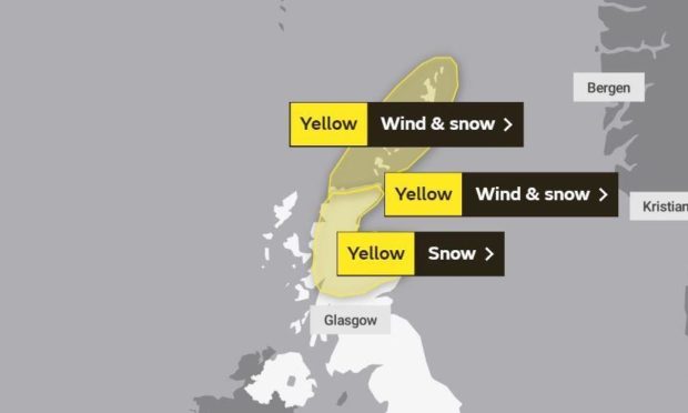
A yellow weather warning for snow remains in place across the north and north-east of Scotland as many residents woke up to a covering of the white stuff.
Sunday evening and the early hours of Monday morning saw snowfall across the region, and experts at the Met Office are predicting more is to fall in the coming days.
Yellow warning for Monday and Tuesday
A yellow warning for snow remains in place for al of Monday in the north and north-east of Scotland, with a separate warning for the islands for wind and snow.
This extends into Tuesday when the yellow weather warning covers the whole region for snow until 10am.
When exactly is snow predicted?
Experts at the Met Office predict that snow will fall in Aberdeen on Monday morning between the hours of 8m and 12pm, before returning later in the afternoon around 3pm.
There will also be snow showers later in the evening heading into Tuesday morning, when snowfall is on the cards for the majority of the day.
The temperature will plummet to -1° on Tuesday with highs of just 2° across the two-day cold snap.
Travel disruption
Strong gales and snow showers were forecast to hit delivering a “taste of winter” for local residents.
Temperatures dropped to -5C in Braemar as others also woke to low temperatures.
Many ferry services across the west coast are disrupted, with some cancelled completely.
“Frequent hail and snow showers will continue through the early hours onwards into Tuesday morning.
A Met Office spokesperson said: “Hail and snow showers will arrive from the north on Sunday afternoon, spreading steadily southwards during the early evening. Whilst by day, accumulating snow is likely to be confined to above 200 metres, snow will still fall to sea level.
“Overnight, accumulations of 1-3 cm of snow are likely. Gales are expected to accompany the snow showers, perhaps leading to temporary blizzard conditions. Gusts of 50-60 mph are expected across the warning area, and perhaps in excess of 70 mph for a short time during Monday morning across the Northern Isles.
“A combination of rough seas and the unusual wind direction will lead to dangerous coastal conditions and particularly difficult conditions for ferry crossings.
“Frequent hail and snow showers will continue through the early hours onwards into Tuesday morning.
“Further accumulations of 1-2 cm of snow are likely for some with higher accumulations likely on some hills and mountains. Conditions will also remain windy with some drifting of snow possible.”
Keep your eyes on the Press and Journal and Evening Express websites throughout the day for the latest travel and weather updates.
