Calendar An icon of a desk calendar. Cancel An icon of a circle with a diagonal line across. Caret An icon of a block arrow pointing to the right. Email An icon of a paper envelope. Facebook An icon of the Facebook "f" mark. Google An icon of the Google "G" mark. Linked In An icon of the Linked In "in" mark. Logout An icon representing logout. Profile An icon that resembles human head and shoulders. Telephone An icon of a traditional telephone receiver. Tick An icon of a tick mark. Is Public An icon of a human eye and eyelashes. Is Not Public An icon of a human eye and eyelashes with a diagonal line through it. Pause Icon A two-lined pause icon for stopping interactions. Quote Mark A opening quote mark. Quote Mark A closing quote mark. Arrow An icon of an arrow. Folder An icon of a paper folder. Breaking An icon of an exclamation mark on a circular background. Camera An icon of a digital camera. Caret An icon of a caret arrow. Clock An icon of a clock face. Close An icon of the an X shape. Close Icon An icon used to represent where to interact to collapse or dismiss a component Comment An icon of a speech bubble. Comments An icon of a speech bubble, denoting user comments. Comments An icon of a speech bubble, denoting user comments. Ellipsis An icon of 3 horizontal dots. Envelope An icon of a paper envelope. Facebook An icon of a facebook f logo. Camera An icon of a digital camera. Home An icon of a house. Instagram An icon of the Instagram logo. LinkedIn An icon of the LinkedIn logo. Magnifying Glass An icon of a magnifying glass. Search Icon A magnifying glass icon that is used to represent the function of searching. Menu An icon of 3 horizontal lines. Hamburger Menu Icon An icon used to represent a collapsed menu. Next An icon of an arrow pointing to the right. Notice An explanation mark centred inside a circle. Previous An icon of an arrow pointing to the left. Rating An icon of a star. Tag An icon of a tag. Twitter An icon of the Twitter logo. Video Camera An icon of a video camera shape. Speech Bubble Icon A icon displaying a speech bubble WhatsApp An icon of the WhatsApp logo. Information An icon of an information logo. Plus A mathematical 'plus' symbol. Duration An icon indicating Time. Success Tick An icon of a green tick. Success Tick Timeout An icon of a greyed out success tick. Loading Spinner An icon of a loading spinner. Facebook Messenger An icon of the facebook messenger app logo. Facebook An icon of a facebook f logo. Facebook Messenger An icon of the Twitter app logo. LinkedIn An icon of the LinkedIn logo. WhatsApp Messenger An icon of the Whatsapp messenger app logo. Email An icon of an mail envelope. Copy link A decentered black square over a white square.

Aberdeen fireworks display: Map and full details to help your Bonfire Night go with a bang

The free display has been moved from its usual spot at the beachfront due to ongoing construction work.

fireworks burst in the sky
Remember, remember the 5th of November. Image: Darrell Benns/DC Thomson.

Every November 5, thousands of people descend on Aberdeen beach to watch the spectacular fireworks display.

The free annual display hosted by Aberdeen City Council has been moved from its usual spot at the beachfront this year due to ongoing construction works.

With limited access and areas fenced off, this year’s display will take place from the North Pier near Footdee instead.

With this new location in mind, we’ve pulled together all you need to know about the big night.

When does Bonfire Night begin?

The fireworks display will begin at 7.30pm.

Is there food and toilets available?

The esplanade is home to catering food trucks which will be open for business.

Close by are some restaurants located at Queens Park including Pizza Hut, TGI Fridays and Burger King as well as independent restaurants like Muzo’s and Cartoos Grill.

Will there be music?

The council confirmed this year’s display will not be to music.

a crowd gathers for Bonfire Night in Aberdeen
Aberdeen’s fireworks display is expected to draw a big crowd. Image: Darrell Benns/DC Thomson.

Where are the best views?

Views can be sought from the esplanade near the Footdee public toilets.

Due to the fireworks being on the North Pier, the opposite side of the harbour will also offer great views – such as along Greyhope Road including some parking north of Greyhope Bay.

People can also enjoy limited views from St Fittick’s Road.

Where can I NOT go to watch Aberdeen fireworks?

Due to the event being at North Pier, people may try to make their way to Footdee for a better look. However, the council is asking crowds to make their way to the esplanade.

A council spokesperson said: “Public viewing will be from the esplanade.

“There will be no public viewing from Footdee and access will be for residents and businesses only.”

The council hopes the event will go with a bang. Image: Darrell Benns/DC Thomson.

Will there be parking/transport?

A park and ride service is available from Bridge of Don, Kingswells and The Aberdeen Altens Hotel.

The park and ride drop off and return pick up point at the beach will be Wellington Street.

The Kingswells park and ride is on the A994 at Kingswells and will operate from 5.50pm with the last bus leaving at 6.20pm.

The Bridge of Don park and ride is based at the old AECC site, off the Ellon Road and will operate buses every 15 minutes, starting at 5.45pm, with the last bus leaving at 6.30pm.

The Souter Head Road park and ride is at The Aberdeen Altens Hotel, off Souter Head Road, and will start operating at 5.40pm with the last bus leaving at 6.10pm.

Disabled parking is available but space is limited and is first come, first serve.

The fireworks display is a much-anticipated event in Aberdeen. Darrell Benns/DC Thomson

Which roads are closed?

These are the road closures in Aberdeen on November 5 for the fireworks display.

From 4pm until 9pm

  • Greyhope Road – St Fittick’s Road and Coast Road

From 5.30pm until 9pm

  • Esplanade – Link’s Road to Beach Boulevard
  • Pocra Quay – full length
  • North Pier Road – full length
  • South Square – full length
  • York Place – full length
  • Wellington Street – full length
  • York Street – full length
  • St Clement Street – full length
  • Clarence Street – full length
  • Waterloo Quay – full length
  • Link’s Place – full length
  • Garvock Wynd – full length
  • Link’s Road from the south junction of Esplanade to Wellington Street
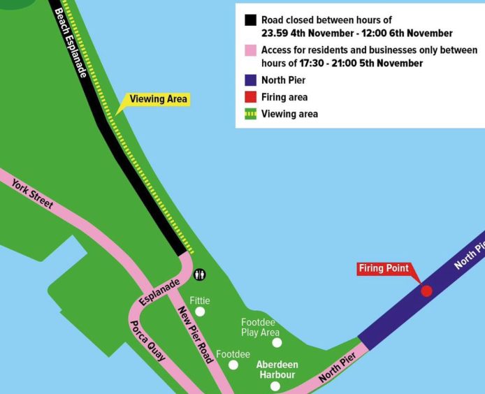
Our map highlights some of the changes to this year’s event. Image: ACC.

From 7pm until 9pm

  • Link’s Road – From Wellington Street to entrance to the Beach Retail Park
  • Miller Street- full length

The esplanade, from the south junction of Link’s Road to York Street Road, will be closed from 11pm on November 4 until 12pm on November 6.

The Beach Boulevard is also closed due to ongoing construction work along the main length.

Conversation