Creag Bhalg, Cairngorms, Scotland
There’s something magical about a modest hill which resides amongst giants, and little Creag Bhalg on the southern edge of the Cairngorms massif is one of the finest examples.
It’s a perfect viewpoint for a short day when the high peaks may be out of bounds. It also offers a variety of options depending on time, mood or inclination, including a longer circuit taking in the impressive cleft of the Clais Fhearnaig.
Our latest excursion to this miniature gem came on an early spring day when winter had made a surprising but brief reprise with overnight snow which was already disappearing fast from under our feet.
We had travelled through the gloom and dark clouds of Glenshee into the brightening skies of Glen Clunie before emerging on Deeside under blue skies and sharpened views.
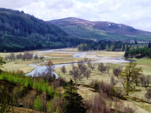
The drive from Braemar round to Linn of Dee was as beautiful as ever, the waters of the Dee twinkling as they swept along at a great lick, deer in great numbers grazing low down at the edge of the pines.
The sparsely occupied car park at Linn of Dee suggested that many had been slower to react to the improving conditions, the already shortened day meaning the high Cairngorms were now unlikely to be an option.
Besides, although we had benign weather at the lower levels, anyone heading for the higher ground would be faced with a different picture.
We left the car park with the snow dropping and dripping from the heavily-laden trees on the short road walk east. We slipped off the tarred surface to continue on the old track running in a parallel direction.
There are branches heading every which way in this woodland but we followed the main line, keeping straight ahead at both crossroads, to eventually come out of the trees on more open ground.
We made a sharp turn left on a path of sorts heading uphill towards a deer fence running across the slope – at one point there is wooden handrail to help upward progress – where there is a stile to avoid any fence clambering.
The tree cover had now thinned out to a minimalist natural art gallery, just the odd skeletal giant as a reminder of a greater spread in days gone by.
The rise to the 657m top was gentle, but the path was in no great rush to get there.
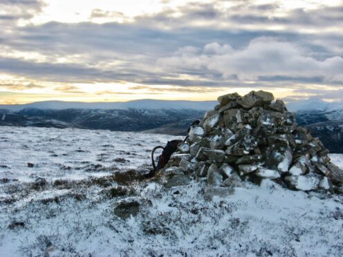
The main summit, with its twin cairns and a stone shelter, was just a few strides away but the views to the big neighbours were forever, the encircling sweep majestic.
Bulky Beinn a’ Bhuird was first to catch the eye, all intricate features lost under a thick blanket of white, while the outrageous tors of Ben Avon were reduced to small breaches on the landscape.
Cairn Toul, Ben Macdui and Beinn Mheadhoin also begged for attention, the huge gaping corries dividing these leviathans exaggerated further by the great white.
Our descent was west towards the sparse woodland of the Doire Bhraghad, at one point passing the poignant sight of a lone, dead pine, its upper limbs raised as if it had accepted surrender to the inevitability of its fate.
As is so often the case with this little hill, we felt we had hit the jackpot so that probably made up our minds not to push our luck by extending the circuit north-east over two smaller rises to visit the Clais Fhearnaig, the deep cleft which cuts between Glen Lui and Glen Quoich.
Instead, we descended west to reach a track at the fringe of the woods for the return journey. All routes eventually reach the bridge over the Lui Water.
You can cross and follow the track and then a path through the trees back to the start but a more aesthetic choice is to stroll down the east bank of the river to reach the road.
ROUTE
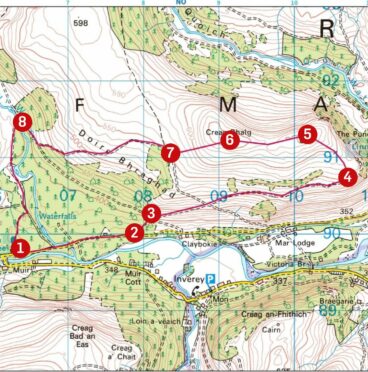
- Exit car park by main entrance at southern end and turn left along minor road.
- After 1.5km, leave road for rough track on left going slightly uphill through trees to reach track junction.
- Go across heading east, passing over another junction and continuing for another 2km until it emerges from trees.
- Turn left (north-west) on a path going uphill, at one point with a wooden handrail, to reach deer fence. Use stile to cross and head up to the 657-metre subsidiary top of Creag Bhalg.
- Continue short distance west on to main summit of the hill where there are twin cairns, a stone shelter and sensational views.
- Descend west towards woodland of Doire Bhraghad until reaching track.
- Follow north for short distance then left on path, which joins track after about 1.5km leading top bridge over Lui Water.
- Turn left over bridge then follow track south and turn right (signed) on path through trees leading back to car park.
INFORMATION
Distance: 11.5km/7miles
Ascent: 320m/1050ft
Time: 3-5 hours
Grading: Pleasant short hill circuit with sensational views. Mostly on good tracks and paths with some walking on minor road, suitable for well-equipped walkers with reasonable levels of fitness. Exposed plateau can be challenging in poor conditions. Ground nesting birds – dogs under close control.
Start/finish: Linn of Dee parking area (NO 063897), £3 per vehicle, free for National Trust members.
Map: Ordnance Survey 1:50,000 Landranger Map 43 (Braemar & Blair Atholl); Ordnance Survey 1:25,000 Explorer sheet OL58.
Tourist Information: VisitScotland, Ballater iCentre, Station Square, Ballater, AB35 5QB (Tel 01339 755306).
Public Transport: None to start, nearest bus service at Braemar.


