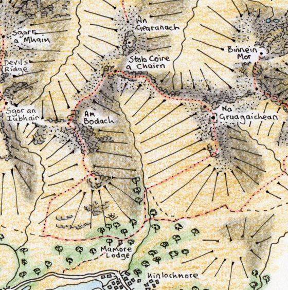
A vehicle track leads east from the Mamore Lodge car park through woodland alive with wildflowers, bees and butterflies in spring and summer.
Follow the track as it goes north into the steep-sided valley of the Allt Coire na Bà. At the point where it crosses the stream, begin to climb north-east up the open slopes of Na Gruagaichean, the Maidens.
On the crest of the ridge you can enjoy the splendid views. At the foot of the long slope is Loch Eilde Mor, the big loch of the hind. Beyond Kinlochleven, the abrupt wall of the Aonach Eagach defines the northern edge of the Glen Coe mountain complex and the sinuous ridges of the Mamores lead the eye far to the west and east.
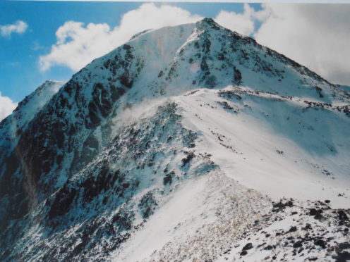
I was up on that ridge with a companion some years ago in April, and as you can see on the photograph, it was snow-covered.
The tall cliffs of Am Bodach, on the far side of Coire na Bà, were cut by deep, snow-filled gullies separated by vertical spines of black rock and looked positively Alpine. There was a dull rumble and an avalanche rolled down one of the gullies, throwing up fine clouds of powder snow. Looking west, we noticed a wall of pale grey rolling towards us along Loch Leven. We pulled up our hoods and turned our backs to the onslaught.
When we were able to turn around and look back down into the corrie, it was wild, with two enormous whirlwinds of snow being blown 4,000 feet up into the cloud above. The snow was soft on south-facing slopes but had a hard crust of ice on north-facing slopes, which made them too dangerous to attempt without crampons and ice axes.
The first Munro, Na Gruagaichean, has a double peak and is known mostly by its English translation, the Maidens. The mountain’s narrow, exposed spine is a fine walk when dry and calm, with very steep sections leading up to the summits.
From the first of the Maidens, sharp ridges curve away gracefully to the south, north-west and north-east, the latter two rising to a peak. From each of these peaks, further ridges curve away up to yet more summits, the pattern repeated as far as you can see.
Descend the very steep slope from the first Maiden then climb the equally abrupt slope to the second. From the top of this second Maiden, a long incline leads down to a bealach which can act as a wind tunnel, so is not the best place to stop for a break. Looking west from here across the giant corrie, Am Bodach, The Old Man, looks formidable, with the last section of its north-east ridge, the route of ascent, appearing impossibly steep.
My first climb up to Stob Coire a’ Chairn was a memorable experience. We were hit by the second wall of snow of the day, hard pellets rattling off our snow goggles. On the summit, the wind howled, we were battered by curtains of snow coming in on it and smothered by swirling clouds of spindrift.
It was on the ridge leading to Am Bodach that the snow suddenly stopped pelting us, the wind dropped, the cloud broke into fragments and the sun’s rays struck the world again. We sat down in the snow to have lunch with superb views north to Ben Nevis, the Carn Mor Dearg Arête and the Grey Corries.
The ascent of Am Bodach provided the greatest challenge of that first walk. It would have been impossible without crampons and ice axe as the snow here was frozen hard.
We were thrilled by the views from the top of the Old Man, particularly of the rest of the Mamores.
Whatever the time of year, this walk will be likely to provide real spectacle, and the last ridge, running south from Am Bodach, does not disappoint. It is steep and narrow, with near vertical cliffs on a massive scale running down to the corrie on the east side. Descend by the long western slope of the ridge and join the track which leads back to Mamore Lodge, where you can enjoy refreshment.
This walk is included in Jack Harland’s book, Highland Journal 1, The Making of a Hillwalker, published by Troubador.
The route
- Directions: On the north shore of Loch Leven, take the A82 to a gate signposted Mamore Lodge, about one kilometre west of Kinlochleven. Follow the drive up to the hotel.
- Distance: 11 kilometres
- Time: Six hours
- Difficulty: For experienced hillwalkers only
- Map used: Ordnance Survey Landranger 41

