Carn Mor, Strathdon, Moray
Every so often there’s a name on a map that jumps out at you, one that intrigues and demands further investigation. Duffdefiance is one of those of names.
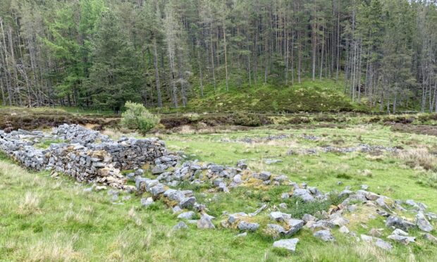
Situated deep in Glen Nochty beneath the Ladder Hills in Strathdon, this ruin was once the home of a colourful character known as Lucky Thain (or Thane) who defied the laird on the Duff Estate by claiming squatters’ rights.
There are differing versions of the legend: some refer to Lucky as male, a wandering man, but most agree that it was an older woman, Eppie Thain, who was notorious in the days of illicit whisky stills and smuggling.
Having been evicted from nearby Glenbuchat for illegal distilling, she and her family managed to build a house overnight and have smoke rising from the chimney the next morning (evicted tenants could not be put out again if they had the lum reekin’), much to the fury of Duff.
The house burned down in 1953 and is now just a scattering of boulders amongst the sheep, but the name, and the intrigue, lives on. For further reading it’s worth checking out the Glenbuchat Heritage Archive.
The ruin was the starting point of the climb to Carn Mor, the highest point of the rounded hills to the north-east. To get there, I had walked through the woods from below Torrancroy, passing the occasional house and eventually the Lost Gallery with its garden of sculptures.
Just beyond the now-closed art studio there is a striking sculpture with its own space amongst the trees, a Matt Toole piece entitled In Ferrous Defense (sic) of the Lost. The tree cover grew thicker, a darker passage for a spell before I emerged into the light again below Duffdefiance.
I followed the old wall of the property uphill on a grassy track, which soon became a narrower path in the heather to cross the edge of Finlate Hill. The height gain had seen the early sunshine being swallowed by shifting mists, the slopes ahead there one minute, gone the next, the appearance of twitching curtains as the neighbours peeked out at the incoming visitor.
At a track junction, I ignored the motorways going left and right and instead took a fainter path dead ahead. It started well, became vague in places (keep left if in doubt) before gaining prominence to climb up to the two marker cairns at the high col.
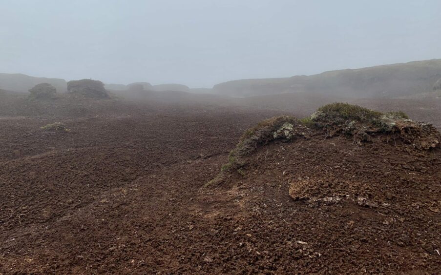
Dun Muir was the first ‘summit’, a lone standing stone marking the top, and then it was a compass line which led through a Monument Valley of peat bogs; high lumps looming out of the grey, constantly twisting corridors with black towering walls. It was eerily silent and strangely beautiful, and best of it all, it was relatively dry giving easy walking.
The occasional white marker post was a welcome aid and soon I picked up the path which trailed the way to the summit of Carn Mor with its trig pillar. The silent treatment continued in the stroll over to Monadh an t-Sluich Leith.
From its small cairn I turned east, staying as high for as long as possible on the left shoulder to avoid the deep heather slopes, eventually coming across the track running down to Long Moss and a red-roofed ruin.
It was now a straightforward route back to Duffdefiance and the spirits of the past, but there were a few stream crossings – one or two unavoidable – which could prove a problem on a wet day.
ROUTE
1. Walk west along road from parking and turn left on rough track between house and cottage. Continue past buildings at Auchernach then Sunnybrae cottage to reach art studio at Aldachuie.
2. Beyond studio, pass prominent artwork situated to your right and keep following track as it swings north-west through darker woodland. When it opens out again, follow the fence along to a gate on the left, go through and cross stream to ruin of Duffdefiance.
3. Take grassy track running uphill beside old wall which becomes rough hill path heading over edge of Finlate Hill to reach a track junction.
4. Ignore tracks going left and right and go straight ahead on fainter path, difficult to follow at times but improving higher up to swing round and reach high col where there are two cairns.
5. Turn left on faint hill path for short rise to standing stone which marks summit of Dun Muir.
6. Head west at first for short distance, then south-west through peat hags to pick up improving path to the trig point on summit of Carn Mor.
7. Continue south-west dipping then rising again to Monadh an t-Sluich Leith (small cairn).
8. Leave east from summit and stay high across left shoulder aiming pick up track which twists south-east downhill.
9. After passing red-roofed ruin, take track branch going left to cross wooden bridge and then follow twisting stream (there’s a few crossings) to arrive back at Duffdefiance and retrace steps back to parking.
INFORMATION
Distance: 20km/12miles
Ascent: 710m/2330ft
Time: 5-7 hours
Grading: Mostly tracks and hill paths but some sections of rough, pathless walking, over featureless high terrain which can be challenging in poor conditions, and some stream crossings may be difficult after rain. Best suited to experienced, well-equipped mountain walkers with good navigation skills. Simple shorter route out-and-back to Duffdefiance. Dogs under close control – sheep on the hill, plus ground nesting birds.
Start/finish: Parking area before bridge below Torrancroy (NJ 335158) off minor road from A97 at Bellabeg.
Map: Ordnance Survey 1:50,000 Landranger Map 37 (Strathdon & Alford); Ordnance Survey 1:25,000 Explorer sheet OL62.
Tourist Information: VisitScotland, Aviemore iCentre, 7 The Parade, Grampian Road, Aviemore, PH22 1RH (Tel 01479 810930).
Public transport: None to start, nearest bus to Bellabeg (No 129) about 3km south of start point.


Conversation