Residents in the north and north-east are expected to visit some of the region’s sunniest beauty spots today ahead of a major change in weather conditions.
Much like yesterday, the forecast remains reasonably warm for spring, with highs of 11c and no sign of rain clouds.
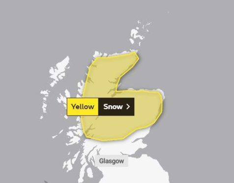
However, this good weather is not expected to last all weekend, with Sunday bringing with it a Met Office yellow warning for wind and snow.
Weather warning
Frequent heavy snow showers are expected across most of northern Scotland on Sunday night and Monday and this may lead to travel disruption.
The warning covers all of the country above Perth, missing out on a small coastal patch along the north-east coast and runs from 6pm on Sunday until midnight on Monday.
It warns that “a very cold northerly airflow will become established across the UK through Sunday night and Monday morning.
“Very strong north to northwest winds will spread hail and snow showers inland across many areas, but the most frequent showers will affect northern Scotland.
“Here, 2-5cm may accumulate at low levels away from north-facing coasts, with 5-10cm above 150m, and 15cm possible on highest ground above 300m.
“The strong winds will cause drifting of lying snow, and blizzard conditions at times on higher ground.”
Strong winds
Residents in the far north Highlands, Orkney, and Shetland also face very strong winds that could reach up to 70mph.
A combination of rough seas and the unusual wind direction will lead to dangerous coastal conditions and particularly difficult conditions for ferry crossings.
This wind and snow warning is in place from 4pm tomorrow until midnight on Monday.
Temperatures in Aberdeen are predicted to dip below freezing, and to as low as -3c overnight on Monday.
The mercury will remain low until Thursday when it will rise to above 5c.
Similar freezing temperatures will also be found across Aberdeenshire, Moray, and the Highlands.


