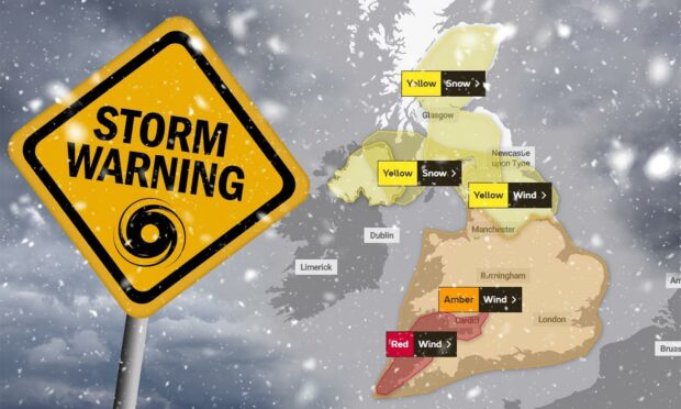
Met Office forecasters have issued several weather warnings for heavy snow and strong winds as Storm Eunice approaches to hammer the UK on Friday.
Just hours after Storm Dudley swept across the country, the meteorological body has now warned of blizzard conditions causing further disruption to travel and power supply.
High-winds of up to 100mph battered most parts of Scotland last night with train and ferry services still bearing the impact of the severe weather.
A number of trains from Inverness and Aberdeen were cancelled on Thursday morning as engineers continue their work to repair the extensive damage caused to the network.
Although the worst of Storm Eunice is expected to hit mainland and south England, most of Scotland is also set to face the harsh conditions of the sixth named storm this winter.
What to expect in the north and north-east?
The Met Office has now issued several weather warnings across the UK – including a yellow alert for heavy snow in the north and north-east of Scotland.
The warning, which covers Aberdeen, Aberdeenshire, Moray and the Highlands, will be in force from 3am until 6pm on Friday as the storm moves south across the UK.
Forecasters are stressing the potential impact of heavy snow and possible blizzards – with some places on higher ground likely to see up to eight inches of the white stuff.
This may lead to significant disruption on the roads and across the transport network, with vehicles and passengers possibly being left stranded due to “very poor” visibility.
Primary routes and pavements in Aberdeen will be gritted twice overnight – once from 6pm on Thursday and again after 4am on Friday – due to the snow forecast.
There is a slight chance rural communities will be temporarily cut off from power supply, with other services such as mobile phone coverage also likely to be affected.
‘Considerable’ risk of avalanches in Scottish mountains
With heavy snow expected to develop on the northern side of Storm Eunice, the Scottish Avalanche Information Service (SAIS) has warned of natural avalanches.
Four out of the five main mountain ranges in north Scotland have been moved to “considerable risk” status – including the Cairngorms, Torridon, Glencoe and Creah Meagaidh.
On Friday, “large” natural avalanches – and in some cases “very large” avalanches – can occur due to the extra amount of snow and the adverse weather conditions.
The Scottish Avalanche Information Service have reported that avalanches are currently at a “considerable” risk status.
Download the Be Avalanche Aware app, check the SAIS avalanche forecasts, blog, & weather forecast and plan your journey accordingly.https://t.co/fvhg2XC4K0 pic.twitter.com/Nho0P2NPVK
— Scottish MR (@ScottishMR) February 17, 2022
SAIS has advised people to evaluate the possible hazards and select their routes carefully as a single person load can also cause an avalanche on some steep slopes.
Human triggered avalanches will be a possibility at the slopes of Lochaber, where a “moderate risk” alert will be in place for the duration of Storm Eunice.
Scottish Government response
With two storms happening virtually one after the other, the Scottish Government is urging people to follow travel advice, which will continue to be updated.
Though a dedicated response team will be working to monitor the situation, it is likely that there will be a significant impact on travel and other essential services.
Deputy First Minister John Swinney said: “Storm Eunice may bring heavy snow and strong winds to much of Scotland from the early hours of Friday, posing further risks to transport and other essential services.
“The Scottish Government’s resilience committee will continue to monitor the situation. We remain in close contact with local authorities and emergency and essential services to ensure people in the affected areas receive the latest information, advice and support where needed.”
Storm Eunice prompts second red weather warning in four months
The Met Office has issued a rare red weather warning as Storm Eunice is expected to bring extremely strong winds and continued disruption for much of the UK on Friday.
While the storm is expected to go relatively easy on Scotland, most of England will bear the brunt of the furious weather -possibly causing similar widespread destruction as Storm Arwen in November last year.
⚠️⚠️🔴 Rare Red Weather Warning Issued 🔴⚠️⚠️#StormEunice will bring extremely strong winds across parts of Southwest England and south Wales
Friday 0700 – 1200
Latest info 👉 https://t.co/QwDLMfRBfs
Advice 👉 https://t.co/JFRa8CtfWY
Stay #WeatherAware⚠️ pic.twitter.com/m46eseAXoV
— Met Office (@metoffice) February 17, 2022
The red alert for wind covers southwest coastal areas of England, where gusts in exposed areas could reach 90mph from early in the morning.
This is the second time the Met Office has issued the rare red alert in the last four months, after Storm Arwen was the first since March 2018 to get the severe warning.
Further inland, an additional amber warning will be in place from 5am to 10pm with winds of up to 80mph expected to cause significant damage to buildings and homes.
