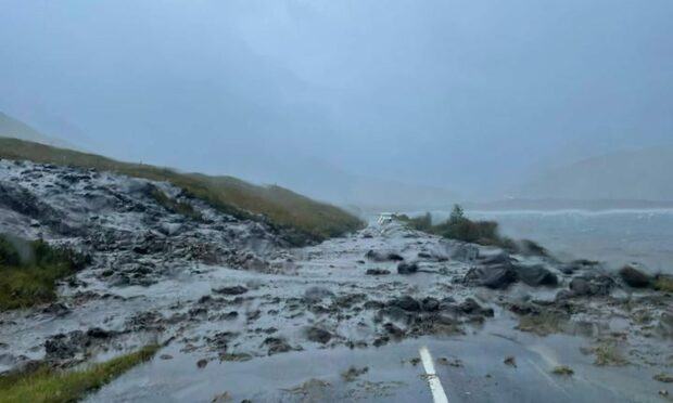
Strong winds and heavy rain battered the north today, causing widespread travel disruption.
The Met Office alerted communities along both the north and west coast as well as on the western and northern isles.
A warning for wind was in place until 3pm on Friday, while a warning for rain expired at 2pm.
Sepa also issued flood alerts across 13 regions.
Transport disruption has been felt across roads, ferries and railways all over the Highlands and islands.
Landslide blocked route to Uig ferry
A landslide blocked the A87 Uig to Kyle of Lochalsh road for a few hours.
The road is used for those travelling to catch a ferry to the Western Isles.
It was closed in both directions at Luib, past Sconser, but was reopened late in the afternoon.
Friday morning ferries on the Skye triangle were cancelled. However, a ferry is due to leave Tarbert in Harris and arrive in Uig at 5pm.
But CalMac warns “All sailings remain liable to weather disruption”.
What areas are covered by the warnings?
Residents in Orkney, Shetland and the Western Isles suffered the strong winds and rain.
But communities stretching the entire length of the north coast were also battered.
☔ Has the rain reached you yet?
🌧️ It's a wet and windy afternoon in most places, as a band of heavy #rain moves east across the UK
⚠️ Expect some spray on the roads and the possibility of small branches being brought down in the strong winds pic.twitter.com/qxSx1N5mGG
— Met Office (@metoffice) September 30, 2022
The warning for rain covered areas of Skye, Oban, Tobermory and Fort William as well as large parts of the central belt.
67mph winds batter islands
Shetland was expected to be worst hit by the conditions as forecasters predicted wind speeds of up to 67mph.
Orkney and the Western Isles were prepared for similar conditions, with gusts of 65mph and 61mph predicted. Portree on Skye will also endure winds speeds of 56mph.
A reminder that you can keep an eye on the conditions at the Braighe here:https://t.co/u0yfSK2NJn pic.twitter.com/n5ETISbQNA
— Comhairle nan Eilean (@cne_siar) September 30, 2022
Residents also experienced a band of heavy rain during the six-hour period of the Met Office rain warning.
Speed limits were imposed on train lines and almost all CalMac routes have either been suspended temporarily or cancelled for the rest of the day.
Bridges close across the north
The Braighe causeway on Lewis and Baleshare causeway on North Uist was closed by police for several hours as result of the adverse conditions.
Churchill Barriers one and two in Orkney, which links the mainland and Lamb Holm, and Lamb Holm and Glimps Holm, have been closed.
Warnings were also issued to drivers on the mainland attempting to cross both the Dornoch Bridge and Kessock Bridge as high winds hamper driving conditions on the crossings.
Met Office forecasters are also warning coastal communities to brace for potential flooding due to rising tides.
Flood warnings issued
Sepa issued 13 flood alerts across Scotland.
Amber warnings have been issued for Argyll and Bute, Skye and Lochaber, Easter Ross and Wester Ross, Orkney and Western Isles.
Aberdeen, Aberdeenshire and Moray were under the amber warning status, however, no weather warnings have been issued by the Met Office for these areas.
There has been reported flooding in parts of the Eastgate Centre in Inverness.
Flooding from rivers and surface water is likely in west and central Scotland today as heavy rain continues. This will cause difficult driving conditions and possibly localised flooding of properties.
Stay up to date with Flood Alerts and Warnings👉 https://t.co/Woujcrq3E3 pic.twitter.com/kjprbrohUV— SEPAFlood (@SEPAFlood) September 30, 2022

Conversation