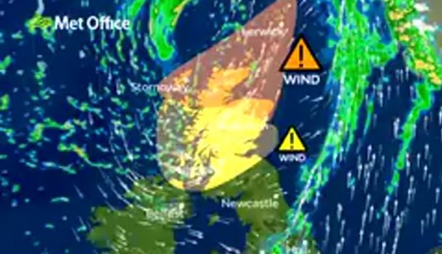
Severe flood warnings were issued last night and major rail, ferry and flight delays are expected across the north of Scotland as Storm Caroline arrives.
Rail services from Aberdeen to Inverness, Inverness to Wick and Inverness to Kyle of Lochalsh will be suspended this morning, and flights to Stornoway, Kirkwall, Sumburgh and Benbecula have all been disrupted.
The Met Office has issued amber wind warnings for the north-east, Moray, the northern Highlands, Orkney and Shetland.
And in Aberdeen, the city’s Christmas Village on Broad Street will be shut all day over fears that high winds of up to 90mph could pose a risk to the public.
The festive market and funfair, which opened at the end of November, attracted 43,000 visitors in its first weekend.
However, the Hann Design Market, which will be host to a number of independent vendors inside the quad of Marischal College from 6pm, will still go ahead as planned.
A statement from Aberdeen Inspired, the city centre business group organising the festival, said: “Due to adverse conditions predicted for Thursday December 7, the Christmas Village will be closed until 5pm.
“It will then be assessed for re-opening and an announcement will be made.
“The safety and care of the public is our priority, we are sorry for any inconvenience this may cause.”
The Met Office said high winds with gusts of up to 90mph could cause major issues across the north-east, northern Highlands and northern isles today.
A forecaster for the Met Office said: “Flying debris is likely, and could lead to injures or danger to life.
“Some damage to buildings is possible, such as tiles blowing off roofs.”
In addition, the forecaster warned of power cuts, large waves and longer journey times.
Elsewhere in Scotland, the Scottish Environment Protection Agency (SEPA) has put out red flood alerts for residents living in the Caithness and Sutherland regions, as well as amber flood alerts for the west coast, the western and northern isles.
West coast ferry operator CalMac also said disruption to ferry services is a “high possibility”.
He added: “We would urge passengers who need to travel, to allow extra time for their journey and to keep track of the status of their sailing on the website setting out on their journey.”
And after the high winds and rainfall of today, the aftermath of Storm Caroline is expected to bring blizzards and ice across the country tomorrow, with remaining snowfall mostly in the north-east on Saturday.
A Met Office forecaster said: “During Friday, increasingly frequent snow showers already affecting parts of Scotland, Northern Ireland and northern England will extend across many of the northern and western parts of the UK.
“2-5cm (0.7 inches to 1.9 inches) of snow is likely fairly widely, with 10-20cm (3.9 inches to 7.9 inches) in places, mainly northern Scotland, Northern Ireland, north Wales and perhaps the north-west Midlands.
“The heaviest and most frequent snow showers will progressively become confined to northeast Scotland during Saturday.”
