Calendar An icon of a desk calendar. Cancel An icon of a circle with a diagonal line across. Caret An icon of a block arrow pointing to the right. Email An icon of a paper envelope. Facebook An icon of the Facebook "f" mark. Google An icon of the Google "G" mark. Linked In An icon of the Linked In "in" mark. Logout An icon representing logout. Profile An icon that resembles human head and shoulders. Telephone An icon of a traditional telephone receiver. Tick An icon of a tick mark. Is Public An icon of a human eye and eyelashes. Is Not Public An icon of a human eye and eyelashes with a diagonal line through it. Pause Icon A two-lined pause icon for stopping interactions. Quote Mark A opening quote mark. Quote Mark A closing quote mark. Arrow An icon of an arrow. Folder An icon of a paper folder. Breaking An icon of an exclamation mark on a circular background. Camera An icon of a digital camera. Caret An icon of a caret arrow. Clock An icon of a clock face. Close An icon of the an X shape. Close Icon An icon used to represent where to interact to collapse or dismiss a component Comment An icon of a speech bubble. Comments An icon of a speech bubble, denoting user comments. Comments An icon of a speech bubble, denoting user comments. Ellipsis An icon of 3 horizontal dots. Envelope An icon of a paper envelope. Facebook An icon of a facebook f logo. Camera An icon of a digital camera. Home An icon of a house. Instagram An icon of the Instagram logo. LinkedIn An icon of the LinkedIn logo. Magnifying Glass An icon of a magnifying glass. Search Icon A magnifying glass icon that is used to represent the function of searching. Menu An icon of 3 horizontal lines. Hamburger Menu Icon An icon used to represent a collapsed menu. Next An icon of an arrow pointing to the right. Notice An explanation mark centred inside a circle. Previous An icon of an arrow pointing to the left. Rating An icon of a star. Tag An icon of a tag. Twitter An icon of the Twitter logo. Video Camera An icon of a video camera shape. Speech Bubble Icon A icon displaying a speech bubble WhatsApp An icon of the WhatsApp logo. Information An icon of an information logo. Plus A mathematical 'plus' symbol. Duration An icon indicating Time. Success Tick An icon of a green tick. Success Tick Timeout An icon of a greyed out success tick. Loading Spinner An icon of a loading spinner. Facebook Messenger An icon of the facebook messenger app logo. Facebook An icon of a facebook f logo. Facebook Messenger An icon of the Twitter app logo. LinkedIn An icon of the LinkedIn logo. WhatsApp Messenger An icon of the Whatsapp messenger app logo. Email An icon of an mail envelope. Copy link A decentered black square over a white square.

A96 accident blackspot heatmap shows where the crashes are clustered

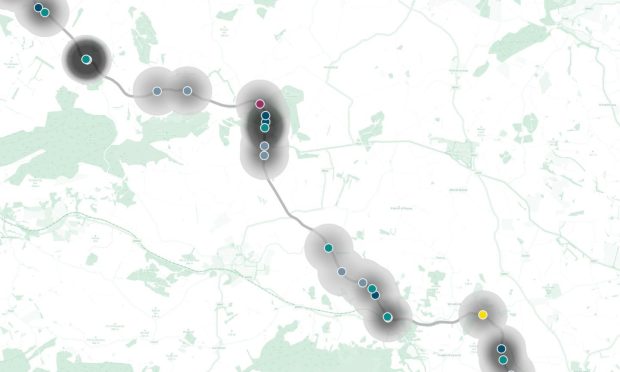
To determine the stretches of the A96 where crashes happen most frequently, our award-winning data team created an accident blackspot heatmap.  

Shows heatmap of crashes on the A96 between 2019 and 2023 based on exclusive analysis
What sections of the A96 saw the most closely clustered crashes between 2019 and 2023?

Viewed from afar, the crashes from five years’ worth of data appear to cover the entire length of the A96.

We have analysed Department for Transport data on more than 100 crashes as part of our investigation into the stretch of road between Aberdeen and Inverness.

To determine where crashes happen most frequently, we created an accident blackspot heatmap.

The heatmap is based on the density of crashes within a one-kilometre radius.

Larger numbers or more closely clustered crashes within that radius appear with a darker shade.

Take a closer look at the most prominent A96 crash blackspots on the map.

A96 crash blackspots in and around Aberdeen

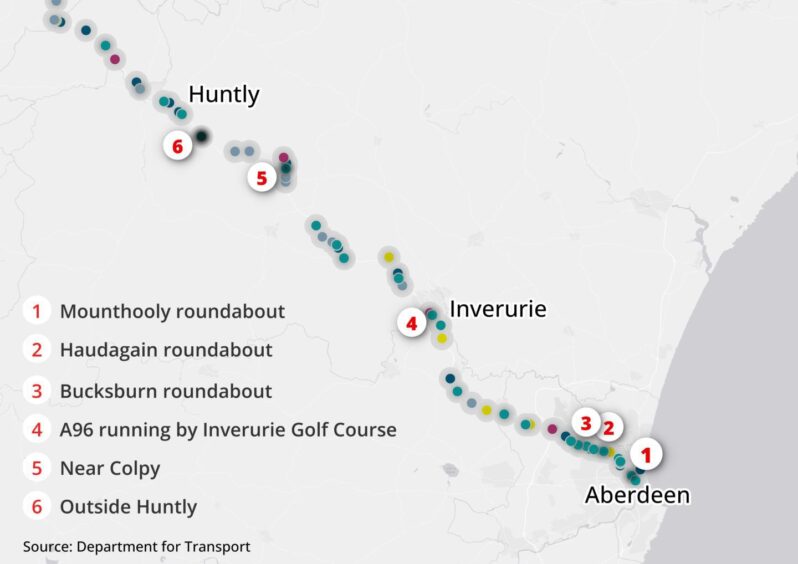
Our heatmap of A96 crash blackspots between Aberdeen and past Huntly. Six darker clusters emerge and are labelled with red numbers in the map. Individual crashes are indicated with coloured points.
The A96 accident blackspots between Aberdeen and Huntly.

Looking closer at the heatmap, blackspot clusters of crashes appear within Aberdeen and past Colpy (3 miles north of Insch).

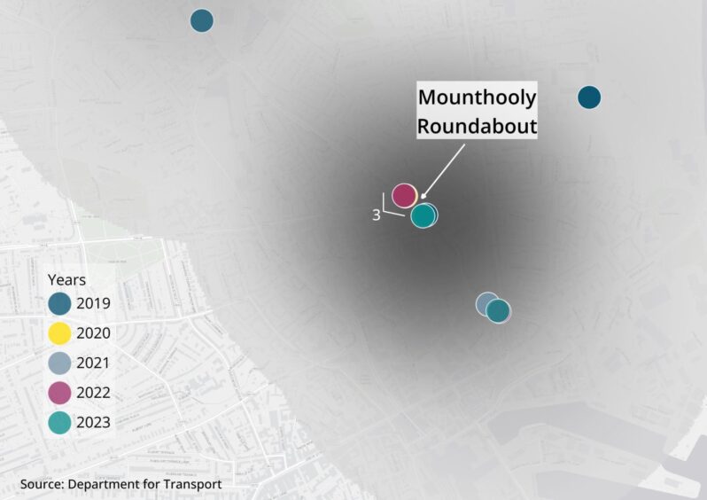
A close-up of A96 crash blackspot near Mounthooly Roundabout with crashes indicated with smaller coloured points.
Firstly, starting within Aberdeen, the first cluster of crashes highlighted within the heatmap is near the Mounthooly Roundabout.

It encapsulates five crashes, two in 2019, and one in 2020, 2022 and 2023. Three of the collisions occurred by the Causewayend junction.

Three of those crashes overlap  and the heatmap indicates the hidden points with a white number.

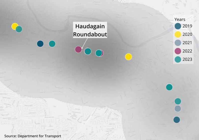
A close-up of A96 crash blackspot near the Haudagain roundabout with crashes indicated with smaller coloured points.
But the next blackspot on the A96 crash heatmap is nearby and consists of five crashes near the Haudagain roundabout.

All five of the crashes took place in 2022 or 2023. Three were classed as serious, the remainder were slight accidents.

Both of the crashes that took place in 2023 were serious.

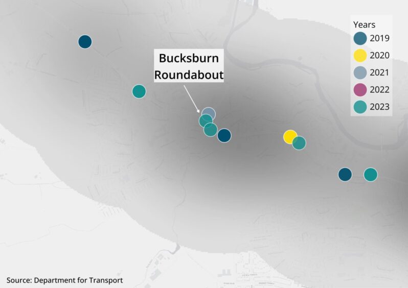
A close-up of A96 crash blackspot on Auchmill Road near Bucksburn roundabout
Another A96 collision blackspot formed on Auchmill Road near Bucksburn roundabout.

This cluster includes a fatal crash in November of 2019. Both of the collisions in 2023 were classed as serious.

In 2024, we reported a teenage boy was hospitalised after a crash by the Bucksburn roundabout.

Officers shut a section of the A96 in the southbound direction for more than two hours after the crash in the evening of August 20.

Travelling further west to Huntly

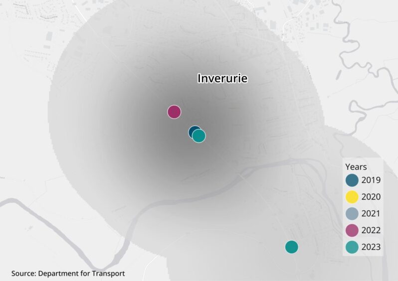
A close-up of A96 crash blackspot near Inverurie Golf Course with three crashes indicated with smaller coloured points.
Three crashes are tightly clustered in a stretch of the A96 running by Inverurie Golf Course.

These crashes, all classed as slight, have a stronger heatmap density due to proximity of the one in 2019 and 2023.

A close-up of A96 crash blackspot near Morgan McVeighs restaurant in Insch with three crashes indicated with smaller coloured points.
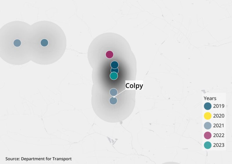
The next blackspot appears near Morgan McVeighs restaurant in Insch with three crashes.

These accidents happened in 60mph sections of the road and officers classed two of them as serious.

In January 2023, two pensioners were hospitalised after a five-vehicle crash near the junction for Morgan McVeigh’s at Colpy.

A close-up of A96 crash blackspot near Huntly with two crashes indicated with smaller coloured points.
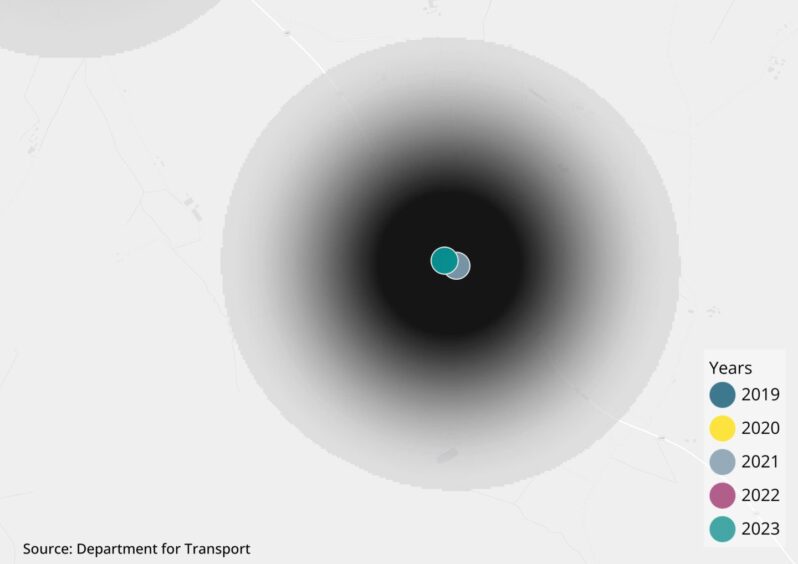
A blackspot near Huntly appears darkest due to the proximity of the two collisions within the 1 kilometre radius.

The 2023 collision was serious and involved eight vehicles.

However, 15 vehicles crashed in 2021 but the incident was classed as slight.

A96 crash blackspots from Huntly to Nairn

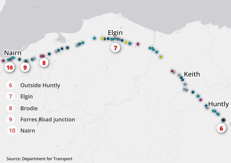
Our heatmap of A96 crash blackspots between Huntly and Nairn. Five areas are highlighted as focus points are labelled with red numbers in the map. Individual crashes are indicated with coloured points.
A96 accident blackspot heatmap shown from Huntly to Nairn.

Travelling further west, there are some three denser sections around Elgin and a number near to Nairn.

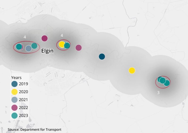
A close-up of A96 crash blackspot near Elgin with three individual clusters of four, four and three crashes. Each crash is indicated with a smaller coloured point.
There are three distinct clusters of crashes near and in Elgin.

From left to right, the first cluster occurred west of Hay Street, two were in 2023. The two to the west of this accident blackspot were serious.

The next darker spot on the heatmap is near Pansport Road – split into two serious and two slight incidents.

In the final cluster there were three serious crashes which took place in 2023 near the Lhanbryde West Roundabout.

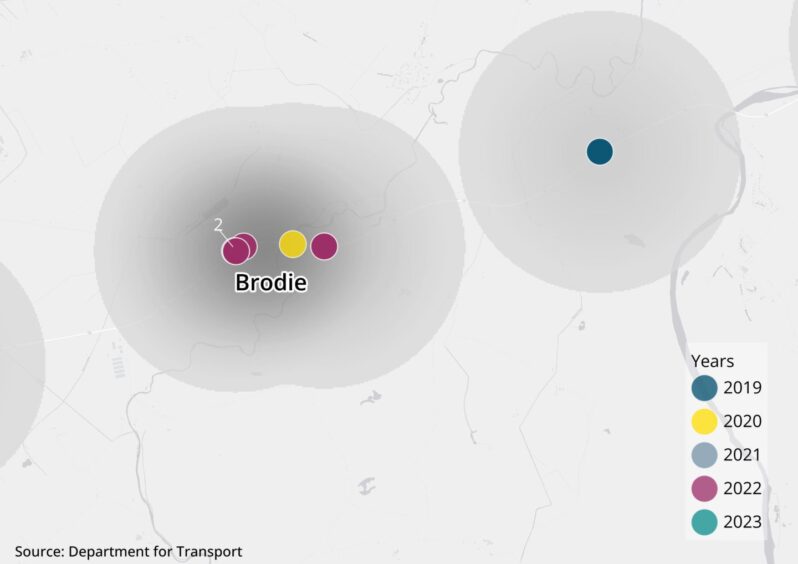
A close-up of a collision cluster near Brodie with five crashes indicated with smaller coloured points.
Meanwhile, this A96 crash blackspot consists of five crashes between 2019 and 2023 near Brodie.

Three of the crashes took place in 2022 – with one almost directly over the location of a 2019 crash.

A crash in 2020, involving a single vehicle, was fatal in this cluster.

Fabian Hall died after he was hit by a vehicle on February 29 2020.

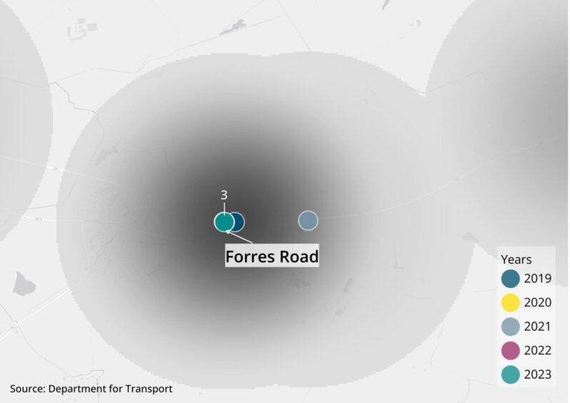
A close-up of A96 crash blackspot near Forres Road with four crashes indicated with smaller coloured points. Three overlap over the 2023 crash and an additional crash from 2021 is on the right edge of the cluster.
Three crashes overlap west of the Forres Road junction with the A96.

The Department for Transport data classed two of those accidents as serious and both took place in 2023. The third was a fatal crash in 2022.

Meanwhile, one crash occurred slightly further east, by Broombank Road junction, in 2019.

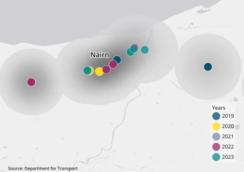
A close-up of collision blackspots in Nairn with crashes indicated with smaller coloured points.
From Tradespark Road to Lochloy Road, there were six serious and four slight crashes in or near Nairn during the time period.

That included a multi-vehicle crash outside the town on December 16 of 2023.

Nairn to Inverness

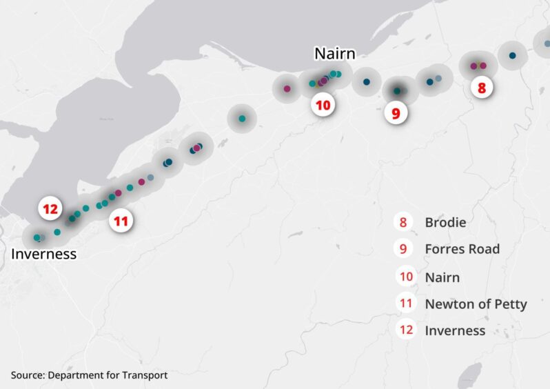
Our heatmap of A96 crash blackspots between Nairn and Inverness. Two additional areas near Inverness are highlighted as focus points are labelled with red numbers in the map. Individual crashes are indicated with coloured points.
The A96 crash blackspots heatmap from Nairn to Inverness.

Finally, approaching Inverness, there are two more stand-out clusters on the heatmap.

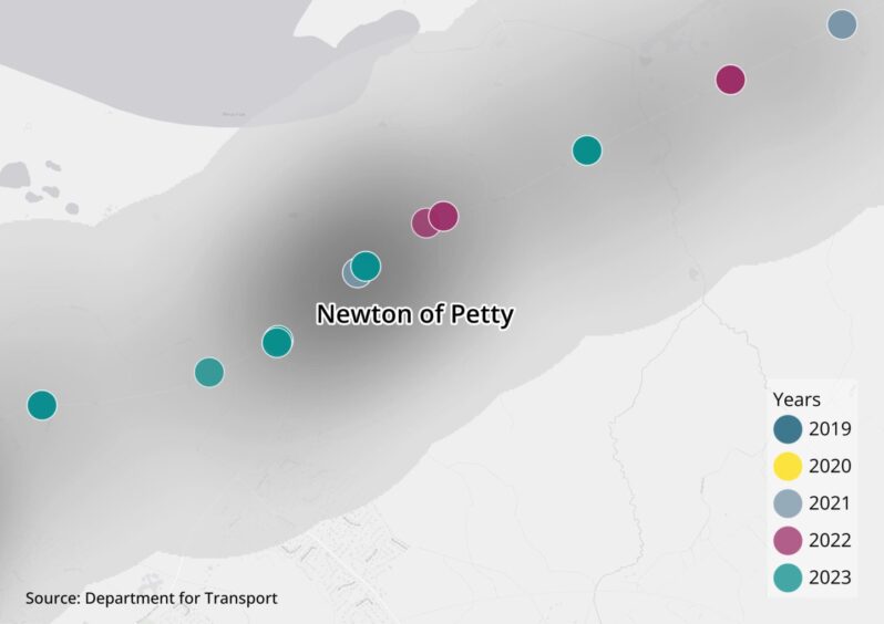
Six crashes occurred between Old Military Rd and Barn Church Road. Map shows the accident cluster near Newton of Petty.
Six crashes occurred between Old Military Rd and Barn Church Road.

Half of them took place in 2023.

Overall, two thirds of them were serious and one third were slight collisions.

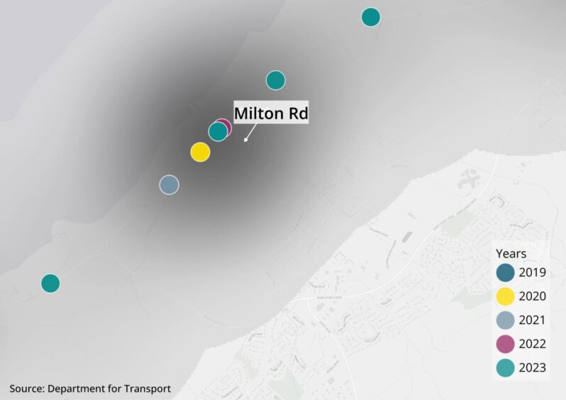
Centred in the blackspot are two crashes that took place by the junction with Milton Road in 2022 and 2023 just outside the official boundaries of Inverness.

The serious collision on Boxing Day of last year involved five vehicles.

Do more A96 crashes happen in urban or rural areas?

Quite a few of the blackspots on our heatmap align with more densely inhabited areas such as city or town boundaries.

The prompted the question of whether crashes are more likely to happen in urban or rural areas.

Using the Scottish Government spatial data on localities, we evaluated whether each crash on the map sits within a locality.

Urban sections of the A96 are those that pass through or are immediately adjacent to larger settlements such as towns and cities.

Only around quarter of the road‘s length runs through these larger settlements (25.35%).

We categorised the remainder of the road as rural – accounting for 74.65% of the 160 km road.

In total, from 2019 to 2023, 78 crashes happened within or immediately adjacent to larger settlements or urban areas.  The remaining 101 incidents happened in rural areas.

Of the urban areas, Aberdeen had the most crashes with 29. The Granite City had the most crashes in 2023 with 12.

It is followed by Nairn and Elgin, both with 10 crashes between 2019 and 2023.

Inverness, while the only other city on the list, only had four crashes.

Read further analysis of A96 crashes with our data deep dive or find our tracker where our live reporters will keep you up to date on known crashes.

Methodology

We used Department of Transport Road Safety Data to find the collisions on the A96 in the past five years.

The data was filtered by the road number to extract the crashes on the major road between Aberdeen and Inverness.

To create a heatmap showing the A96 crash blackspots, we used mapping software QGIS to calculate the density of crashes within a one-kilometre radius.

Scottish Government spatial data on localities was applied to a vector of the A96 road and the points of the crashes for further urban versus rural analysis.
Conversation